|
CASE STUDY - Fauna-focussed
Ecological Restoration at Monjebup North, South Coast, Western Australia
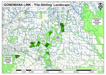
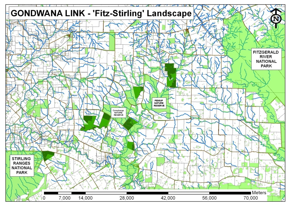
Figure 1: (click image to enlarge) A map of the Fitz-Stirling landscape,
an actively engaged operational area of Gondwana Link, where properties
located between the Stirling Ranges and Fitzgerald River National
Parks have been purchased and restored to increase the connectivity
of this fragmented landscape. Clearly visable in the image are the
Corackerup and Peniup Nature Reserves, along with 8 properties purchased
specifically to contribute to the Gondwana Link vision. The 400
ha of cleared land featured in this case study - part of Bush Heritage
Australia's larger Monjebup Reserve - is the dark green area circled
in red
Ecosystem type
Monjebup North's ecosystems are best defined as a semi-arid mixed
mosaic of Open Shrub Mallee and Low Woodland vegetation associations.
In 2011, Threshold Environmental Pty Ltd was commissioned by Bush
Heritage Australia (BHA) to develop an Ecological Restoration Plan
based on the analysis of soils, surrounding vegetation, and fauna
habitat preferences. Seven main plant communities were identified
for re-establishment according to soil type, including several types
of Mallee, Open Woodlands, and a Swamp Woodland (Figure 2).
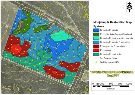
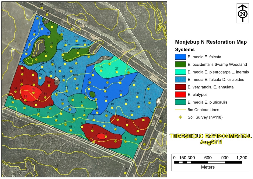
Figure 2: (click image to enlarge) The broad ecosystem types as they
could have occurred at Monjebup North prior to the clearing of 400
ha for agriculture. This map builds on soil sampling data and vegetation
survey data.
Landscape condition
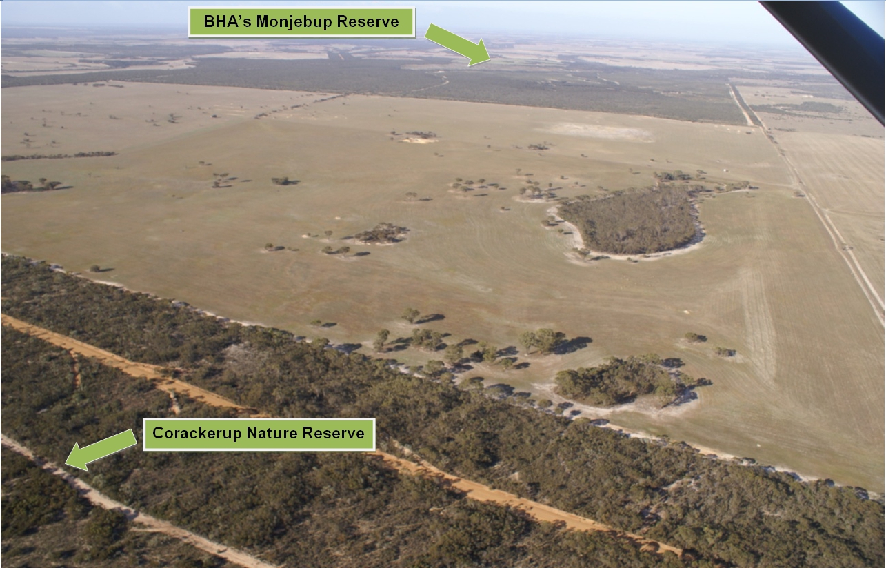
Monjebup North was purchased by Bush Heritage Australia for its
significant proportion of remnant native vegetation in a global
biodiversity hotspot (Figure 1). The property purchase included
the acquisition of a 400 ha area of cleared agricultural land, which
presented a zone of fragmentation between areas of remnant vegetation
in the south of the property (Bush Heritage Australia's Monjebup
Reserve) and the Corackerup Nature Reserve located to the north
(Figure 3).

Figure 3: (click image to enlarge) Aerial image capturing the cleared
areas on Monjebup North taken during a fly-over in 2009. The photo
was taken from the northwest corner of the site, looking towards
the southeast.
Restoration goals
The restoration of Monjebup North's cleared areas aims to significantly
increase ecological connectivity within the local landscape. The
outcomes of the project are conservation-focused, in particular
the expansion of habitat access opportunities for the unique and
diverse fauna and flora of the Fitz-Stirling region.
Works undertaken
After building a restoration map for the entire property in 2011,
the north-western corner (100ha) of Monjebup North was subjected
to a restoration program by Threshold Environmental Pty Ltd in 2012.
Several restoration techniques were used (Figure 4), including:
Direct seeding of 8 different seed mixes matched to soil type
(species count more than 100 species); Planting seedlings of species across the whole site as well as
in soil-specific “node” plantings; Hand-broad seeding of ‘rare’ seed in patches of targeted
soil types; Development of habitat debris piles to encourage the return and
occupancy of fauna, particularly ground-dwelling reptiles, marsupials,
and native rodents; On-site burning of serotinous species from the Proteacea family
and subsequent in-situ seeding; Chipping and mulching of select species for mechanical broadcast
in contour graded ‘seams’.
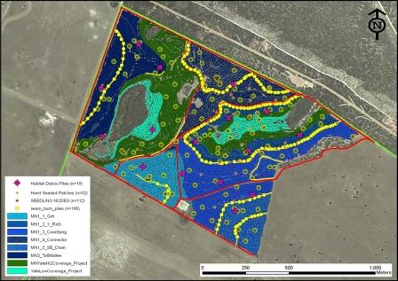
Figure 4: (click image to enlarge) The 2012 post-restoration
operational map showing the 7 meter tractor passes direct-seeding
8 different seed mixes across the entire 100 ha area, and the additional
detailed, location-specific restoration treatments.
Threshold Environment Pty Ltd is currently implementing the restoration
program for 150 ha on the eastern side of the property (2013).
Monitoring methodology
In November 2012, Threshold Environment Pty Ltd established a total
of 21 long-term monitoring plots (15m x 15m) across the 8 vegetation
systems seeded across the site. The monitoring counts all native
species found within the plots, which enables identification of
changes in germination, plant density and species composition over
time (Figure 5).
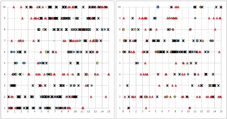
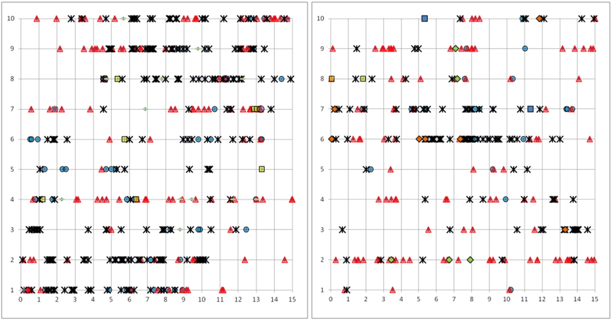
Figure 6: (click imiage to enlarge) Visual output from two 15m x 15m monitoring plots following
direct-seeding. The Y-axis captures 10 seeding rows (spaced at 1.4
m); the X-axis presents the exact location of each recorded germinant
(m). Genera-specific germination data is presented using different
symbols. The first monitoring results - 4 months after direct-seeding
- indicate that there is strong germination across the site, with
a good representation from all the main genera (Eucalyptus, Acacia,
Melaleuca, Gastrolobium and Calothamnus). Excellent levels of survival
for the hand-planted seedlings (mainly Banksia and Hakea species)
were also noted. Monitoring will be ongoing.
Additionally, Bush Heritage Australia is also monitoring the site
with a specific focus on the presence of vertebrate fauna and birds.
To date, 10 monitoring locations have been established, including
5 locations within the re-vegetated area and 5 reference sites in
adjacent remnant vegetation.
Lessons Learned and Future Directions
The restoration of patch-like vegetation communities as found in
south-west WA requires a detailed approach which is at odds with
industrial methods of broad-scale restoration. However, by layering
different restoration treatments on top of each other, this contradiction
can be overcome. For example, while the core vegetation structure
and composition can be established through broad-acre direct-seeding,
genetically viable sub-populations of less ubiquitous species can
only be added through manual planting in specifically targeted soil
types, thereby creating densely planted pockets of a given species
("nodes"). Future challenges lie in the restoration of heavy, impenetrable
soils, the fine-tuning of seed quantities needed for direct-seeding,
refinement of the design of habitat debris piles and other fauna
microhabitat, and the successful establishment of sedges and native
grasses.
Stakeholders and Funding
The restoration of Monjebup North is an initiative of Bush Heritage
Australia contributing to the Gondwana Link vision, made possible
through Wildlife Corridor funding by South Coast Natural Resource
Management.
Contact details for this case study:
Threshold Environmental Pty Ltd
Justin Jonson, Director
P.O. Box 1124, ALBANY WA 6331, Australia
+61 (0) 427190465
[email protected]
www.thresholdenvironmental.com
To promote your successful restoration project on this website please return your completed casestudy form to Mr Vern Newton, and do not forget to include some pictures of your success.
For details of current ecosystem rehabilitation or restoration projects already showing promising results in Australia please visit the Ecological Management and Restoration Project Summaries page.
For information relating to case studies of a global nature please visit the Global Restoration Network (GRN) website, a project of the Society for Ecological Restoration (SER).
|